|
|
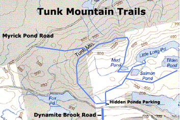
| The north trail is not pictured. |
Tunk Mountain
Tunk Mountain is 1157 feet high, and it is located between Franklin and Cherryfield on the
Blackwoods Road (route 182). You can hike four different trails to reach the peak.
Tunk Mountain
- Southwest Trail via Myrick Pond Road
This route involves driving north on the Myrick Pond road, which
located just west of the mountain off the Blackwoods Road. Drive up this dirt road 0.4 miles, and the road splits. Take the
right-hand turn (east) and at the 0.7 mile mark are two sets of three boulders. A right turn at these boulders climbs steeply,
is less traveled, and unpassable by car. I usually park here and start walking up the hill to the right (east). You'll travel
about a mile on this road, and then the road will have a big pile of brush in the middle. At this point, look to your right,
and you'll see a large, car-sized rock with blue paint. A trail starts here, crosses a small brook, and follows an old logging
road. After you reach the top of a small hill, look for a left-hand turn, where the trail narrows and ascends the west side
of the mountain. You'll follow along a series of cliffs through the trees to your right. Eventually, you'll reach a clearing
that offers nice views to your west. Here, turn east a bit, and continue the steep climb through rough terrain, and you'll
reach a plateau on top. Enjoy the easy walking through the woods and then finish the climb up to the peak. There's a lot of
open rock on top, and you'll love the view of the other nearby mountains.
Tunk Mountain - Northern Route
via Myrick Pond Road
Directions here start from the begining of the Myrick Pond Road. Drive up this dirt road 0.4 miles, and the road splits.
Take the right-hand turn (east) and continue. At the 0.7 mile mark, you'll see the two sets of three boulders. Park here
and walk past these boulders, which the Nature Conservancy likely placed for our benefit. At the 1.3 mile mark, you'll
see another junction. Stay to the right (east). At the 1.7 mile mark, you'll see the cliffs on Tunk Mountain to your east.
At the 2.1 mile mark, you'll see a wooden stake in the ground on the right side of the road (east) at the top of a small
hill. Park here. The trail climbs steeply through the woods, passing over and under a number of blowdowns. Eventually, the
trail levels out near a recent clearcut. The trail climbs steeply again. You'll pass an open rock face on your right.
Beyond this rock face, the trail reaches another open rock face, over which the passage is aided by a rope. At this point,
you'll have a great view to the west. The trail continues up towards the peak from here. This trail can be combined with the
above trail for a nice big hiking loop.
Tunk Mountain - South-to-North Route (via Hidden Ponds Parking Area)
If you are driving
east on the Blackwoods Road from Franklin, two miles after you pass Fox Pond, you'll see the Dynamite Brook Road on your right,
which is a dirt road that immediately climbs a steep hill. Just past this road is more obscure road on your left (north side
of Blackwoods Road), which provides access to Hidden Ponds parking area. I usually park beside road, walk down the dirt road
to the junction of Hidden Ponds Trails and Tunk Mountain trails. Turn left (due west) and head towards Tunk Mountain. Alternatively,
if you go straight (due north), you will go to Hidden Ponds. The Tunk Mountain trail meanders somewhat close to the Blackwoods
Road for a while, climbs an interesting notch, and then reaches an open rocky area. Just past this point, the trail goes through
some bushes and blowdowns, and behind which you reach a small rocky point. Take a left turn (west). Do not go straight (north).
To the north is actually a property line, which goes nowhere interesting that I know of. Anyway, take this left, cross a beautiful
small brook, and start climbing the southern end of Tunk. Eventually, you'll reach the same plateau described in the first
route (be sure to remember that this trail joins up with the first trail, so don't get lost on the return trip).
Tunk
Mountain - Eastern Route (via Hidden Ponds Parking Area)
Start this trail at the same parking area described
above. But, instead of turning left (west) onto the Tunk Mountain trail, continue north on the Hidden Ponds trail. The first
pond you'll reach is Salmon Pond. Continue along the left (west) side of the pond, and you'll see a trail junction. Take a
left, climb a small hill, and the trail will take you around Mud Pond. Walk around this pond, and then start climbing the
east face of Tunk. Eventually, you will get above treeline and you'll be on exposed rock for quite a while. There are ropes
to help you up the rocks, but the rope isn't completely necessary. You'll reach the top of the mountain and actually hike
a bit west to reach the peak. This trail can be combined with the "South-to-North Route" for a hiking loop.
|