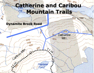
Catherine Mountain
Catherine Mountain (942 feet elevation) can be reached by two different
trails. If you drive up the Dynamite Brook road a few miles, you'll eventually see a small bridge. Before this bridge is a
small parking area on your left (south of the road). Park here, and the trail heads south on a relatively flat slope for a
while. The trail begins a relatively sharp ascent to a trail junction. Go straight ahead (east) for Catherine. Turning right
(southeast) takes you to Caribou. The trail climbs the western side of Catherine. Watch for cairns (piles of rocks) to help
guide you. When you reach a large open rock that climbs sharply to your left, this is the start of a small loop. If you complete
the loop, you will return to this same point. Climb up this open rock and you'll see a chair made out of stone. Watch out
for wasps. Continue east and the trail eventually comes to a junction after passing a small swampy/brook area. If you turn
left, you'll head towards the eastern part of Catherine, which can be accessed from another parking area. Instead, bear right
and you'll enjoy some really nice views of Acadia and eventually complete the loop back at the huge open rock.
To
hike the eastern ridge of Catherine, you'll want to park at the top of the hill just to the west of Tunk Lake. There's a parking
area off the road, and the trail starts heading west from this point. 15 minutes up the trail, before you get any great views
of the island to your south, the trail splits. Take a minor detour to the right (turning east) and check out the Catherine
Cliffs. These cliffs provide a nice view of Spring River Lake and Tunk Mountain. Return to the main trail, and you can continue
a relatively long walk up Catherine Mountain. You'll pass places where there are signs of mining. Here's a
map of the mining area. Eventually this trail connects with the trail described in the above paragraph.