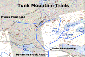
Tunk Mountain
Tunk Mountain is 1157 feet high, and it is located between Franklin and Cherryfield on the Blackwoods Road (route 182). You can hike four different trails to reach the peak, although only one trail is official.
Tunk Mountain - Eastern Route (via Hidden Ponds Parking Area)
This is the official trail. If you are driving east on the Blackwoods Road (route 182) from Franklin, two miles after you pass Fox Pond, you'll see the Dynamite Brook Road on your right. Just past this road is a parking area on your left (north side of Blackwoods Road), which provides access to Hidden Ponds parking area. An old and unmaintained trail turns left (due west) and head towards Tunk Mountain. Continue straight (due north), you will go to Hidden Ponds and the main trail. Continue north on the Hidden Ponds trail. The first pond you'll reach is Salmon Pond. Continue along the left (west) side of the pond, and you'll see a trail junction. Take a left, climb a small hill, and the trail will take you around Mud Pond. Walk around this pond, and then start climbing the east face of Tunk. Eventually, you will get above treeline and you'll be on exposed rock for quite a while. There are ropes to help you up the rocks, but the rope isn't completely necessary. You'll reach the top of the mountain and actually hike a bit west to reach the peak.
Tunk Mountain - South-to-North Route (via Hidden Ponds Parking Area)
This is an old and unmaintained trail makes it somewhat possible to hike Tunk as a loop from the eastern side. Adventure and navigation required. The trail described here is overgrown and hard-to-follow. The author recommends hiking the official trail to the peak and returning to the parking area via this unmaintained trail. Directions - Hit the peak on the main trail, follow the ridgeline south into a level wooded area with views on both sides, trail splits and turns east to drop down the ridgeline (the trail below intersects here and turns right / west), drop elevation, cross a small brook, intersect a property line marked red running north south from the west, turn right here, drop through an interesting notch, walk parallel to 182 for a while, wade through wet areas, and intersect the main trail just a minute below the parking area. Because the trail heads south and east from the peak and ridge, a hiker will eventually run into route 182 if heading south.
Tunk Mountain - Southwest Trail via Myrick Pond Road
This infrequently traveled route involves driving north on the Myrick Pond road, which located just west of the mountain off the Blackwoods Road. Park at the first and immediate parking area and walk up this dirt road 0.4 miles, and the road splits. Take the right-hand turn (east) and at the 0.7 mile mark are two sets of three boulders. The trail described below continues north. Instead, take a right turn at these boulders and climb up a rocky hill passing boulders on the right. Pass a small bog / pond. After about a mile of this section, the road splits kind of, stay right and look for a large boulder with old blue spray paint marking the trail. Turn right onto this trail, cross and small brook and follow an old logging road. When the trail becomes open rock and a small hill, look for a left turn. The trail narrows and ascends the west side of the mountain. You'll follow along a series of cliffs through the trees to your right. Eventually, you'll reach a clearing that offers nice views to your west. Here, turn east a bit, and continue the steep climb through rough terrain, and you'll reach a plateau on top. This trail intersects with the South to North Trail described above. Enjoy the easy walking through the woods and then finish the climb up to the peak.
Tunk Mountain - Northern Route via Myrick Pond Road
Not many people have hiked this trail in years....Directions here start from the beginning of the Myrick Pond Road. Park immediately and walk up this dirt road 0.4 miles, and the road splits. Take the right-hand turn (east) and continue. At the 0.7 mile mark, you'll see the two sets of three boulders. Walk past these boulders, which the Nature Conservancy likely placed for our benefit. At the 1.3 mile mark, you'll see another junction. Stay to the right (east). At the 1.7 mile mark, you'll see the cliffs on Tunk Mountain to your east. At the 2.1 mile mark, after climbing a small hill and seeing water on the right for a while, you'll see a wooden stake, exhaust pipe, and rocks piled on the ground on the right side of the road (east) at the top of a small hill. The trail climbs steeply through the woods, passing over and under a number of blowdowns. Eventually, the trail levels out near a recent clearcut. The trail climbs steeply again. You'll pass an open rock face on your right. Beyond this rock face, the trail reaches another open rock face, over which the passage is aided by a rope. At this point, you'll have a great view to the west. The trail continues up towards the peak from here. This trail can be combined with others for a nice big hiking loop.